


TENSPACE
TENSPACE
【TENSPACE】Laser RTK measuring instrument, GNSS receiver, high-precision satellite positioning, Beidou, GPS
- Small and lightweight, easy to carry, simple to operate
- The results include CSV, CAD, and PDF formats
- Contactless measurement
 30-day money-back guarantee
 1-year warranty
Couldn't load pickup availability
20 in stock
Details and Features
Details and Features
Tenspace Surveyor is a portable surveying and mapping device customized by Baotu Technology for non-professionals. It integrates satellite navigation, laser, and other positioning and ranging technologies, featuring simple operation and on-site mapping.
Specifications
Specifications
Product Name: Tenspace
Satellites:BDS:B1I/B2I/B3I/BIC/B2a/B2b
Laser color: green
Waterproof performance: IP65
Weight: 320g (including battery)
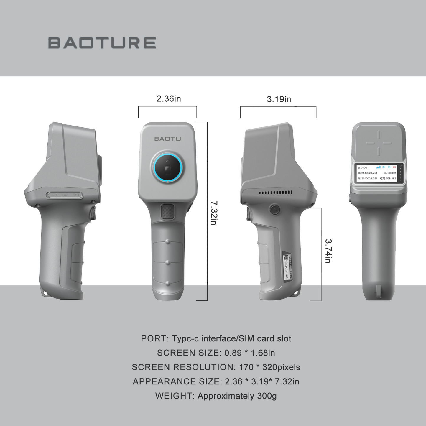
Appearance size: 2.36*3.19*7.32in
Screen size: 0.894*1.68in
Battery: 7000mAh, operating time 8h+
Shell material: ABS+PC
Static accuracy: Horizontal: 土 (2.5+0.5×10⁻⁶×D) mm
Vertical: 土 (5+0.5×10⁻⁶×D) mm
RTK accuracy: Horizontal: 土 (8+1.0×10⁻⁶×D) mm
Vertical: 土(15+1.0×10⁻⁶×D) mm
Laser range: 30m
Working temperature: -45℃~+75℃
Storage temperature: -55℃~+85℃
Package contents
Package contents
- 1x storage bag
- 1x User Manual
- 1x certificate of conformity
- 1x warranty card
- 1xUSB charging cable
- 1x charging head
- 1x lanyard
- 1x adapter
- 1x measuring rod
- 1x tenspace


Asked Questions
Asked Questions
- 1-year warranty;
- Scan the QR code to download the software;
- Manually enter the CORS account;
- We are here to assist you! Please visit our "Contact Us" page to get in touch with us.


Routine surveying
- It possesses conventional RTK surveying and mapping capabilities. Based on the Beidou, GPS, and GLONASS systems, it achieves centimeter-level precision positioning.
- The Tenspace comes with a built-in screen, which can directly display X, Y, and elevation information.
- The software supports the import of CAD and SHP files, as well as setting out and volume measurement.

Contactless measurement
Equipped with a 30m laser, it can directly obtain the coordinates of the laser point position, enabling non-contact measurement.

Multiple achievements
- Supports the generation and export of results in multiple formats, including CAD, DAT, SHP, and PDF
- Support one-click sharing through third-party programs, facilitating the printing and sharing of measurement results